


CANYON G

nordan
User
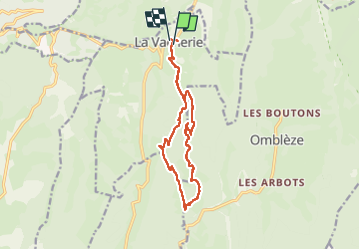

Length
14.3 km

Max alt
1015 m

Uphill gradient
554 m
Km-Effort
22 km

Min alt
642 m

Downhill gradient
551 m
Boucle
Yes
Creation date :
2025-05-03 08:00:45.701
Updated on :
2025-05-03 13:29:27.629
3h47
Difficulty : Medium

FREE GPS app for hiking
 SityTrail
IGN / Geographical institutes
SityTrail Plus
The world is yours!
About
Trail Walking of 14.3 km to be discovered at Auvergne-Rhône-Alpes, Drôme, Le Chaffal. This trail is proposed by nordan.
Positioning
Country:
France
Region :
Auvergne-Rhône-Alpes
Department/Province :
Drôme
Municipality :
Le Chaffal
Location:
Unknown
Start:(Dec)
Start:(UTM)
672509 ; 4972678 (31T) N.
Comments
galère avec le chien mais contournable. bien